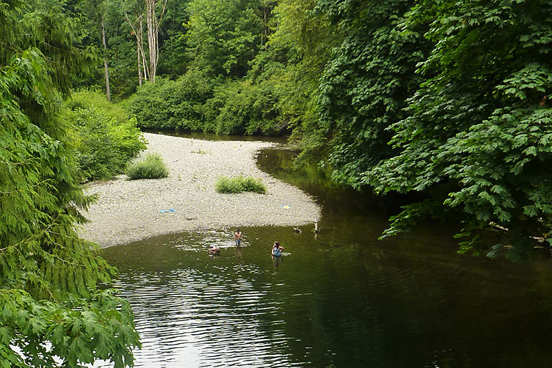
What are your favourite places to take a cool, refreshing dip in the summer? If Bright Angel Park is on your list, you’re in good company! Folks have been swimming there for generations, and it’s no secret that the water is cool at this time of the year.
Why is the water cool?
Great question! It has to do with where the water is coming from at that particular time and place: from surface water, from groundwater, or from a mix of both sources. In places like Bright Angel Park, cool water flows out of the ground and into the river. Over the summer, the volume of water flowing in the river decreases and there is more groundwater than surface water in the mix.
Let’s learn a few terms and dive into why this happens.
- Surface water enters a stream or river as snowmelt or rain.
- Groundwater enters a stream from underground.
- Stream water is often a mix of surface water and groundwater, but sometimes it is only one or the other. This depends on time and place.
Stream water only has surface water in some places in springtime. In these places, groundwater flows below the stream or it isn’t present at all.
Stream water only has groundwater in some places in the summer. In these places, it has stopped raining and rain and snow that fell earlier in the year have drained away.
Stream temperature varies by the amount of energy coming from the sun, air, and materials in the streambed. As the flow in one place along the stream changes from gushing to trickling, the water temperature rises higher and faster there until the water is gone.
Imagine you are drawing water to take a bath. If you only turned on the hot water tap, the bath would be too hot! When you add cold water, it mixes with the hot water and cools the tub of water down to a comfortable temperature to bathe in. If you only turned on the cold water tap, your bath would be cool and you would add hot water to make it more comfortable.
Think of the river having two taps of water flowing into it: a groundwater tap and a surface water tap.
- Groundwater tap: this water stays consistently cool. It is usually around 10ºC.
- Surface water tap: this water is sometimes warm, sometimes hot, and sometimes cool. The temperature changes depending how long the water has been receiving heat from the sun above, from rocks below, and from rain draining and falling into the river. In sunny and shallow spots, surface water can get as warm as 20ºC.
Step into the river in a few different places. How warm or cool is it?
- If the water is cool, it is likely that the mix has more groundwater than surface water in it.
- If the water is warm, it is likely that the mix has more surface water than groundwater in it.
Why does river water stay cool when it’s hot outside?
When snow has melted and rain has stopped falling, it’s like the surface water “warm tap” has turned off. Snowmelt and rainwater that has already fallen will continue to move downstream (or be used by plants and animals) but no more water from that “tap” will be added to the river until the next rain.
Why is stream water warm in other places in the watershed?
When there is no groundwater flowing into a specific place along a stream, it’s like the “cold tap” is off there. Once all the surface water has drained past that point, the stream goes dry.
In Streamflow Snapshot 2, we learned that:
- A gaining stream has more water flowing into it than out. It is gaining water from the ground.
- A losing stream has more water flowing out than in. It is losing water to the ground.
- A disconnected stream is not in contact with groundwater anywhere along its course.
We also learned that a stream can be gaining in one place and losing or disconnected in other places along its course. That relationship can change by season, too!
In general, gaining streams only change temperature by 1-2ºC. The temperature stays pretty consistent because the cool groundwater has a moderating effect.
The temperature of losing streams can swing up or down by about 5ºC. It takes a lot of energy to heat up water, so a 5-degree change is a BIG change!
Since disconnected streams only have surface water flowing in them, it’s as if only the “warm tap” is turned on.
How warm or cold is the river water? How does this compare to streams that flow into the river?
Check out this map of the Xwulqw’selu watershed prepared by PhD candidate Kristina Disney. Click on a yellow circle to open a line graph of water temperature at that site. Notice how the water temperature has changed in that place over the summer and as compared to 2021 and 2022.
Note: This is a sneak peek! Kristina continues to refine the map and update the data in the graphs. Please be patient; it may take a moment for the page to load.
The mix of groundwater and surface water – and the volume of water – can change meter by meter and day by day along streams and rivers. That’s why it’s important to look for general patterns in data by place and time.
What can I do now?
- Go for a walk in the watershed and look around you. Notice how warm or cold the water is. What makes it so?
- Share this Streamflow Snapshot with your family, friends, neighbours and co-workers. Have a conversation about what you’re learning and what else you want to know.
- Talk with a friend or neighbour and listen to those who may be struggling with the drought and water restrictions in their lives and livelihoods. Being there for one another with compassion and empathy through these tough times can make a real difference.
- Join a Stream Team to monitor the flow of water in Xwulqw’selu streams and creeks. Our teams of volunteers are active through the end of September. Contact Jennifer Shepherd at jshepherd@uvic.ca or call her at (236) 800-9011 to sign up or learn more.
Recent Comments