Now you see it. Now you don’t.
Water’s the talk of the town these days. So far this summer, it has barely rained in the Xwulqw’selu watershed. Signs tell us not to water our lawns or wash our cars. Neighbours compare notes about whose well has gone dry and when. Farms and businesses without a water license have been told to stop using water to grow their crops. Some streamflow monitors have noticed that a particular creek is dry in one place, yet it flows in another. Other residents look at their local stream and scratch their heads, wondering why they can’t pump water when, from what they can see, the flow looks to be the same as it’s always been.
You may be asking…
- Why do some streams go dry while other streams continue to flow during a drought?
- What makes a stream go dry then have water flowing in it again, even if it hasn’t rained?
- Where specifically will a stream, creek or river go dry? When will that happen?
- Where does the availability of surface water and groundwater change the most or least within the watershed when there are changes in climate, water use and land use?
- Which “IFs” related to climate, water use, and land use changes have the biggest impacts on groundwater discharge and recharge?
… and why care about answers to these questions anyway?
Answers to questions like these can help farmers, for example, choose which crops to plant based on how much water the crops take to grow and when to expect a harvest.
Learning about the flow of water in Xwulqw’selu Sta’lo’ helps us to understand how much surface water and groundwater we can expect to be available in different places in the watershed throughout the year and with the passage of time. Understanding the impact of changes in the water cycle helps us to adapt our practices and lifestyles.
Ok, so what’s going on?
Water loves to move. It will take the easiest path – in, out, down or up – and in response to changes in climate, land use, and the amount of water we pump and use.
- Surface water flows above ground along streams and rivers and is the water that flows INTO (and OUT of) lakes, ponds, and the ocean.
- Groundwater flows underground and fills in all the spaces between plant roots, soil particles and sediment like silt, sand, clay, and gravel as well as the deeper rocks. Aquifers are places that store or move water underground.
- Water can flow from the surface DOWN into the ground. This “recharges” the aquifer.
- Water can also flow from the ground UP to the surface as “discharge” from the aquifer.
The direction of water flow (from the surface to the ground, or vice versa) can change depending on what is happening in the air, elsewhere on the ground, and underground. With constant changes in activities on the land, in the weather, and how much water we are using to live, there are constant changes in fresh water’s movements, too.
What affects where water goes?
Take a moment and look around you. What do you notice about the land, buildings, plants, humans and animals in this place? What makes it the same or different from other places you know well?
If you were to make a list of these similarities and differences, how might they impact how water moves here and there? Here is a list to help you! Consider these factors that determine how water moves, where it travels, how quickly it moves, and when it gets from A to B.
Above ground
- Topography: the elevation and slope of the land
- How fast the water is travelling
- The type of soil and other natural deposits on the surface of the land
- What vegetation is present (and how much water is released through evapotranspiration)
- What buildings, roads, and other infrastructure is present and how they affect runoff
- What ecological and human activities take place on the land
- Where depressions are found on the surface of the land where water can travel in channels (in creeks, streams, and rivers) seasonally or all year round
Underground
- Which types of soil and rocks are beneath our feet
- How thick and porous these materials are
- How much water is present and where it is in the watershed at a moment in time
- How fast the water is travelling and how much water the materials can store, given how thick and porous they are in different places of the watershed
- How easy is it for water to flow through aquifers
- Where wells are located and their capacity to hold water
At the ground surface
The factors listed above will impact whether a stream continues to flow with more, less, or about the same volume of water at any moment in time.
- A connected stream is in contact with groundwater.
- A gaining stream has more water flowing into it than out. It is gaining water from the ground.
- A losing stream has more water flowing out than in. It is losing water to the ground.
- A disconnected stream is not in contact with groundwater anywhere along its course. The stream is losing water, but a much smaller amount of water than the amount lost in a losing stream.
Some streams are always disconnected. Others become disconnected from groundwater when the water table falls below the stream bed and thus groundwater and surface water are no longer connected.
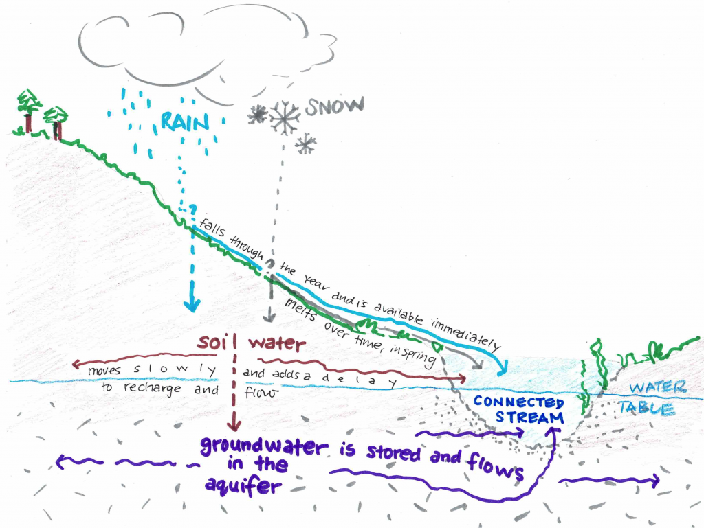
Figure 1: Connected stream. Groundwater is in contact with the stream.

Figure 2: Disconnected stream. The water table is below the stream bed so groundwater is not in contact with the stream.
Pumping water from wells can lower the water table and change a gaining stream into a losing stream or a disconnected stream.
Surface water and groundwater connections naturally vary through space and time. One spot at a stream or river can change its connection with groundwater as the seasons change. However, groundwater-surface water connections are becoming less reliable during critical windows of times that sustain the river ecosystem during the summer.
Where have we seen stream connections change in Xwulqw’selu this summer?
Our research team is starting to look at the data and think about how we might offer an answer to this question. Check back later in 2023 or 2024 for updates on our research outcomes.
In the meantime, continue to read our Streamflow Snapshots as we post them this summer. Learn about trends that show our increasing reliance on groundwater through the summer and differences in these trends over time and place in the watershed.
What can I do now?
- Go for a walk in the watershed and look around you. Notice the landscape and life here, and what impacts how water moves.
- Share this Streamflow Snapshot with your family, friends, neighbours and co-workers. Have a conversation about what you’re learning and what else you want to know.
- Talk with a friend or neighbour and listen to those who may be struggling with the drought and water restrictions in their lives and livelihoods. Being there for one another with compassion and empathy through these tough times can make a real difference.
- Join a Stream Team to monitor the flow of water in Xwulqw’selu streams and creeks. Our teams of volunteers are active through the end of September. Contact Jennifer Shepherd at jshepherd@uvic.ca or call her at (236) 800-9011 to sign up or learn more.
Recent Comments