Geospatial Librarian Daniel Brendle-Moczuk participated in an expedition to assist UVic’s Mountain Legacy Project led by Eric Higgs. The team summited four peaks in 12 days to take approximately 50 repeat photographs from various historical surveyors, such as the photographs taken by Allison B. Grant of Mount Alderson in 1953.
This year, the team was accompanied by vegetation and soil PhD student from the UK, who was not able to bring a soil sampler across the Atlantic. Daniel thought about how a soil corer could be constructed, so he went by UVic Facilities knowing they might have old hollow fence and sign posts. Daniel told the facilities folks about the graduate student’s needs, and they volunteered right then and there to make a soil sampler using an old fence post. The student was able to collect their samples because of our supportive community at UVic.
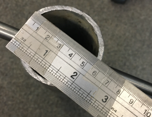

UVic Facilities generously made a soil sampler for a UVic researcher by using an old fence post.
Daniel shares a typical day on the mountain:
- hike/scramble several hours to mountain ridges/summits helping to carry camera equipment, safety gear, warm clothing, sustenance, etc
- set-up above to obtain repeat images as close as possible to original surveyors’ (glass plate archival) images (could take 2-3hrs)
- record azimuth, coordinates, weather (temperature, wind direction/speed, barometric pressure, humidity, etc); brief narrative of #1 above re: routes and how weather affected #2 above and any changes throughout the 2-3hrs
- help pack everything away
- hike/scramble back down helping to carry equipment
- take soil & vegetation samples on the way down back to the trail(s)
- (once back at either base camp or at research accommodations in town of Waterton…) download images, tidy #3 above
- clean & prepare equipment for next day
- repeat
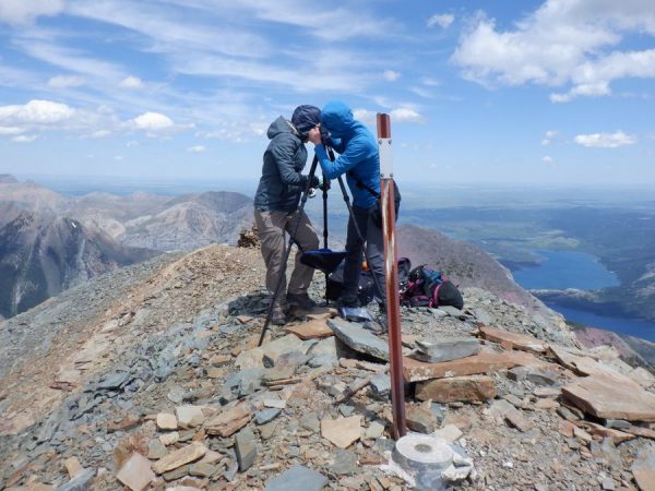
Mt. Alderson, July 9, 2022 (2692m)